ALERT DAY: Snow returns this afternoon and evening
ALERT DAYS
- SATURDAY AFTERNOON AND EVENING (12/13): ACCUMULATING SNOW
- SUNDAY (12/14): EXTREME COLD
WEATHER HEADLINES
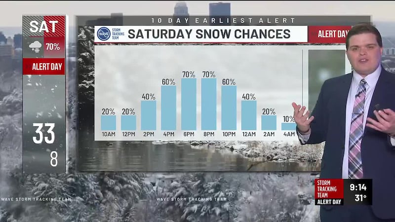
- NEXT 12: Higher accumulations of 1 to 2 inches expected north of I-64; isolated amounts up to 4″ possible
- SHORT TERM: ALERT DAY continues Sunday due to extremely cold temperatures and wind chills below zero
- LONG TERM: Slow but steady warm up into next week
FORECAST
LOUISVILLE, Ky. (WAVE) - Saturday is another WAVE Weather Alert Day with more snow moving in this afternoon and evening. Accumulations are likely, especially north of I-64. Expect highs in the 20s and low 30s.
Snow on Saturday evening will cause travel issues as temperatures crash into the single digits. Another 1 to 2 inches of snow is possible, especially north of the Louisville Metro. The snow moves out after midnight.
Our Alert Day continues Sunday due to extreme cold. Some areas could see wind chills as low as -10° to -15° Sunday morning. Wind chills hover near or below zero all day while actual temps top out in the low teens. Clouds clear Sunday afternoon.
Sunday night will be downright frigid. Expect lows in the single digits, especially in spots with snow still on the ground. Wind chills near and below zero are still likely, although the wind will not be as strong as it was earlier on Sunday.
Temperatures remain below freezing all day Monday, but we’ll be able to recover to near 30° by the afternoon under mostly sunny skies.
The rebound continues midweek with highs well into the 50s by Thursday! That warm up comes to an abrupt halt Thursday afternoon and evening as our next cold front brings rain and perhaps a few rumbles of thunder.
Copyright 2025 WAVE. All rights reserved.