ALERT DAY: Another dangerously cold night ahead
ALERT DAYS
- UNTIL 10AM MONDAY (EXTREME COLD)
WEATHER HEADLINES
- NEXT 12: Lows in the single digits for all areas tonight; some near zero where snow is on the ground
- SHORT TERM: Slow warm up begins with highs near 30° Monday afternoon
- LONG TERM: Next system to watch brings rain and wind Thursday
FORECAST
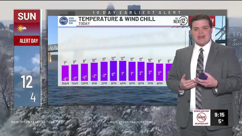
LOUISVILLE, Ky. (WAVE) - Sunday night will be downright frigid as lows fall into the single digits and potentially to near 0° in spots with snow on the ground. The wind chill will not be much of a factor, but you’ll still need to take extra precautions Monday morning.
After a frigid start Monday morning, we’ll slowly rebound to the upper 20s and low 30s during the afternoon under sunny skies. Mostly clear and cold Monday night. Lows in the teens and 20s.
Mostly sunny and warmer Tuesday with a few more clouds into the afternoon. Highs in the 30s and low 40s.
We climb to near 50° Wednesday despite more clouds and a small rain chance.
The warm-up peaks Thursday with highs in the mid 50s and comes to an abrupt halt Thursday afternoon and evening as our next cold front brings rain and perhaps a few rumbles of thunder.
We’ll turn sharply colder Thursday night as the cold front sweeps through. Lingering moisture may allow for a few snow showers.
Even if we don’t see snow showers, residual moisture on roadways may freeze into black ice as lows crash into the 20s.
Copyright 2025 WAVE. All rights reserved.