FORECAST: Thawing out with milder temperatures and even some rain & thunder later this week
WEATHER HEADLINES
- NEXT 12: Clear and cold, but not quite as cold as previous nights with lows in the 10s and 20s
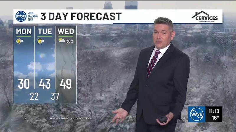
- SHORT TERM: Highs in the 40s on Tuesday, 50s by Wednesday
- LONG TERM: Warmth peaks on Thursday with rain, wind, and thunder, more snow showers by early Friday
FORECAST
LOUISVILLE, Ky. (WAVE) - It’ll be cold tonight, but not nearly as cold as previous nights with lows down into the teens and lower 20s by Tuesday morning. We’ll keep a mostly clear sky through the overnight hours.
Tuesday is when we’ll finally see a break from the cold as milder air from the south arrives. Highs will be in the 40s for most with a mainly sunny sky Tuesday afternoon.
We’ll see an increase in clouds Tuesday night, which will in turn help keep temperatures from dropping below the 30s for lows early Wednesday morning.
A few sprinkles are possible on Wednesday as a weak system moves in from the west, but most look to stay dry and mild with highs in the 50s during the afternoon.
A band or two of rain, wind, and thunder are likely on Thursday as a cold front plows through the region. Highs will be in the mid to upper 50s on Thursday as this happens.
Snow showers wrapping in on the backside of this system late Thursday night into early Friday morning will need to be watched as some light accumulations can’t be ruled out. We’ll have more details on that as we get closer.
Copyright 2025 WAVE. All rights reserved.